
About
First known as Gilmantown, the town was home to the Gilman family, of which there were twenty-four members receiving land grants. At one time it was the second-largest town in the state, following Portsmouth. The original town was larger than it is now, with villages and parishes including Belmont, Gunstock Parish, Hurricane, Tioga, Factory Village, and Lakeport. Original boundaries of the town were Alton, Barnstead, Loudon, Canterbury, Northfield, Winnipesaukee River and Winnisquam Bay. A parish first called Averytown, the site of an unprofitable iron-mining enterprise, is still known as Gilmanton Iron Works.
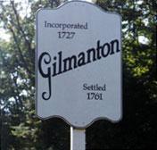
Gilmanton was incorporated in 1727 and the Charter was signed on the 20th of May by his Majesty's Colonial Governor, John Wentworth. The conditions of the new charter were: proprietors must build seventy dwelling houses and house a family in each within three years of the charter. They also needed to clear three acres of land for a planting and a meetinghouse must be built for religious worship within four years. They also needed to build a house for a minister and build a school. If anyone defaulted they would lose their share of the land.
The town was not settled until 1761 because of the fear of the Indians along with a land dispute with John Tuffon Mason who owned much of the land in New Hampshire. Among the first to live year-round in Gilmanton were the Mudgett brothers, John and Benjamin in 1761. In 1762 more families arrived by 1767 there were forty-five families living in town.
Currently, Gilmanton remains a quaint and quiet town. It is much smaller in land size and its town boundaries are now Alton, Barnstead, Belmont, Canterbury, Loudon, and Pittsfield. The town is still predominantly rural and it has two village areas, the Corners and the Iron Works each with its own post office and small grocery store.